
Arlington
Quick Facts at a Glance
Jurisdiction Type: Arlington is an independent county with no incorporated municipalities, meaning it functions as both a city and a county under Virginia law.
ZIP Codes: 22201, 22202, 22203, 22204, 22205, 22206, 22207, 22209, 22213
Population: Approximately 238,000 residents (2023 estimate)
Land Area: 26 square miles, making Arlington the smallest self-governing county in the United States
Distance to Washington, D.C.: Arlington shares the Potomac River border with Washington, D.C., and some of its closest neighborhoods are less than one mile from the U.S. Capitol
Metro & Transit Access: Served by WMATA’s Orange, Blue, Silver, and Yellow Lines, with 11 Metro stations, including Rosslyn, Ballston-MU, Pentagon, Crystal City, and Reagan National Airport (DCA)
School System: Arlington Public Schools (APS) is a single unified K–12 district serving approximately 28,000 students across 38 schools
Key High Schools: Washington-Liberty High School, Yorktown High School, Wakefield High School, H-B Woodlawn Secondary Program, Arlington Career Center.
Median Household Income: Approximately $120,000 (U.S. Census ACS 2022)
Historical Note: Arlington was originally part of the 10-mile-square District of Columbia, was retroceded to Virginia in 1846, and officially became Arlington County in 1920
Overview & Geography
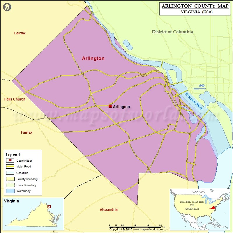
Arlington County covers 26 square miles on the west bank of the Potomac River, directly adjacent to Washington, D.C. It is the smallest self-governing county by area in the United States. The county borders Alexandria (City) to the south, Fairfax County to the west and north, and the District of Columbia and the Potomac River to the east.
Key geographic corridors include Wilson and Clarendon Boulevards (the Rosslyn-Ballston corridor), Columbia Pike (connecting Fairfax County to the Pentagon area), Route 50/Arlington Boulevard, and Jefferson Davis Highway (Route 1) running along the eastern edge near Amazon HQ2 and Reagan National Airport.
The county's density is notable: with roughly 238,000 residents packed into 26 square miles, Arlington's population density (~9,200 per sq mi) rivals many major American cities, yet large portions remain characterized by single-family neighborhoods with tree-lined streets.
Named Neighborhoods & Communities
Arlington is organized around distinct, named neighborhoods. Below are the most commonly referenced communities buyers should know:
Rosslyn — High-density skyline corridor; multiple Metro lines; closest Arlington point to Georgetown.
Ballston — Major employment node; Ballston Quarter mall; Ballston-MU Metro station (Orange/Silver).
Clarendon — Dining, bars, and retail hub; vibrant nightlife; Clarendon Metro station.
Virginia Square — Quieter node between Clarendon and Ballston; GMU Antonin Scalia Law School campus.
Pentagon City — Fashion Centre mall; Blue/Yellow Line Metro; near Amazon HQ2.
Crystal City / National Landing — Amazon HQ2 headquarters site; Crystal City Metro; Reagan National Airport adjacency.
Shirlington — Walkable village; home to Signature Theatre (Tony Award-winning); independent restaurants.
Lyon Village / Lyon Park — Established residential; mix of 1930s–50s homes and new construction near Clarendon.
North Arlington — Encompasses Donaldson Run, Country Club Hills; larger lots; top-rated school pyramid.
Aurora Hills / Nauck — South Arlington; more affordable entry price points; proximity to Pentagon and I-395.
Columbia Pike Corridor — Diverse, multicultural strip; affordable apartments; revitalization investment ongoing.
Cherrydale / Maywood — Suburban feel in north Arlington; single-family homes; walkable to Ballston.
Schools & Education
All public school students in Arlington County are served by Arlington Public Schools (APS), a single unified K–12 district. APS operates 28 elementary schools, 5 middle schools, and 5 high schools (plus special programs), serving approximately 28,000 students.
High Schools
The county's three comprehensive high schools are Washington-Liberty High School (zip codes 22201, 22205, 22207), Yorktown High School (22207, 22213), and Wakefield High School (22204, 22206). Additionally, H-B Woodlawn Secondary Program (grades 6–12) operates as an application-based alternative program known for its student-centered, democratic governance model. The Arlington Career Center offers technical and career education programs for high school students.
Higher Education
George Mason University's Antonin Scalia Law School is located in Virginia Square. The University of Virginia Northern Virginia Center and multiple other graduate programs maintain a presence in the Rosslyn-Ballston corridor, making Arlington a hub for continuing and professional education.
School Assignment
Elementary school assignment in APS is address-based. Because APS boundaries are periodically redrawn, buyers should verify current school assignments directly with APS before closing on a property, particularly in transitional border areas between school pyramids.
Transit, Commute & Walkability
Arlington is one of the most transit-accessible jurisdictions in the Washington metro region. The Washington Metro (WMATA) serves the county with four lines and eleven stations:
Orange & Silver Lines: Rosslyn, Court House, Clarendon, Virginia Square-GMU, Ballston-MU
Blue Line: Rosslyn, Pentagon, Pentagon City, Crystal City, Ronald Reagan Washington National Airport
Yellow Line: Pentagon, Pentagon City, Crystal City, Ronald Reagan Washington National Airport
Rail commute times from key Arlington stations to downtown D.C. (Metro Center): Rosslyn (~6 min), Ballston (~18 min), Pentagon (~10 min). Commuting by car to central D.C. via I-66, Route 50, or the George Washington Parkway typically takes 20–40 minutes depending on traffic; HOV restrictions apply on I-66 inside the Beltway during peak hours.
Reagan National Airport (DCA) is located within Arlington County (ZIP 22202) and is served by Metro's Blue and Yellow Lines. The county also maintains an extensive network of Capital Bikeshare stations and W&OD Trail and Mount Vernon Trail for cycling and running.
Major Employers & Economy
Arlington's economy is anchored by federal government presence, defense contracting, and a fast-growing technology sector. Key employers include:
The Pentagon — U.S. Department of Defense headquarters; ~23,000 military and civilian employees on-site; located in ZIP 22202
Amazon — HQ2 (National Landing / Crystal City); currently housing thousands of corporate employees with major expansion underway
Boeing — corporate headquarters relocated to Arlington in 2022; offices in Pentagon City area
CACI International, Leidos, Booz Allen Hamilton — major defense and intelligence contractors with significant Arlington presence
Arlington County Government — major public-sector employer
George Mason University (Antonin Scalia Law School) — Virginia Square campus
Parks, Landmarks & Community Life
Landmark Sites
Arlington National Cemetery (ZIP 22211) spans 639 acres with more than 400,000 interments. The Pentagon is both a working federal facility and a recognized historic landmark. The Netherlands Carillon and Marine Corps War Memorial (Iwo Jima Memorial) stand near Rosslyn.
Parks & Trails
Long Bridge Park (22202) on the Potomac waterfront features athletic fields, an aquatics center, and D.C. skyline views. Bluemont Park provides access to the W&OD Trail. Lubber Run Community Center and Park anchors the Lyon Park neighborhood. Potomac Overlook Regional Park in north Arlington offers wooded hiking above the river.
Arts & Culture
Signature Theatre in Shirlington won the Tony Award for Regional Theatre in 2009 and regularly stages world-premiere productions. The Arlington Arts Center serves the visual arts community.
Farmers Markets
The Arlington Farmers Market at Courthouse Plaza (Saturdays, year-round) is one of the oldest continuously operating farmers markets in the region. The Columbia Pike Farmers Market (Sundays, seasonal) and Ballston Farmers Market (Thursdays, seasonal) serve other parts of the county.
Frequently Asked Questions
Is Arlington, Virginia its own city or part of a larger county?
Arlington is an independent county under Virginia law — not a city, and not part of any larger county. It has no incorporated municipalities within it. The county government functions as both the city and county government, handling all local services including schools, police, zoning, and property taxes. This is an important distinction from neighboring Fairfax County, which contains numerous incorporated cities and towns. There is no "City of Arlington" in Virginia.
What are the public schools like in Arlington, and how does the assignment process work?
Arlington Public Schools (APS) is a single unified district serving all of the county. It consistently ranks among the top school districts in Virginia and the Washington metro region. There are three comprehensive high schools — Washington-Liberty, Yorktown, and Wakefield — plus H-B Woodlawn, an application-based 6–12 alternative program.
Elementary school assignments are based on home address, and boundaries are periodically adjusted. Buyers should verify current school assignments with APS before purchasing, as boundary lines can change.
How easy is it to commute from Arlington to Washington, D.C.?
Commuting from Arlington to D.C. is among the most convenient in the metro region. The Washington Metro (WMATA) serves 11 stations in Arlington across four lines. Rail travel from Rosslyn to Metro Center takes roughly 6 minutes; from Ballston, approximately 18 minutes. Reagan National Airport (DCA), accessible by Metro's Blue and Yellow Lines, is located within the county. Car commutes vary significantly; I-66 has HOV/express lane restrictions during peak hours.
What is the housing market like in Arlington, and is it a buyer's or seller's market?
Arlington has historically favored sellers due to constrained land supply, high demand from federal workers and tech employees, and limited new single-family construction. The median sale price across all property types is approximately $700,000 as of 2024, with single-family homes in desirable school zones frequently exceeding $1 million. Condos in the Rosslyn-Ballston corridor and Pentagon City offer lower entry price points, typically starting around $350,000. Contact our team for current days-on-market and inventory data for your specific target area.
What major employers are located in Arlington, Virginia?
Arlington is home to some of the region's most significant employers. The Pentagon, headquarters of the U.S. Department of Defense, employs approximately 23,000 military and civilian personnel (ZIP 22202). Amazon's second headquarters (HQ2) is being built in the National Landing/Crystal City area. Boeing relocated its corporate headquarters to Arlington in 2022. Major defense contractors including CACI International, Leidos, and Booz Allen Hamilton maintain large presences in the county.
What is National Landing, and how does it differ from Crystal City?
National Landing is a rebranded planning district encompassing Crystal City, Pentagon City, and the Potomac Yard area in south Arlington (plus a small portion of Alexandria). The name was created in 2018 in connection with Amazon's HQ2 selection and is used primarily for planning and economic development purposes.
Crystal City and Pentagon City remain the common colloquial names for their respective neighborhoods. Both are served by Metro's Blue and Yellow Lines and adjacent to Reagan National Airport (DCA).

Our Arlington Market Expertise
Our team has been actively representing buyers and sellers across Arlington County for 13 years and our agents have been consistently recognized as Top Producers by Arlington Magazine including for the most recent year, 2026. Our agents have closed transactions from first-time buyer condos near the Rosslyn-Ballston corridor to luxury condos selling for more than two million dollars at the Pierce, one of the DC region’s premier condo destinations. We have also helped sellers with luxury single-family homes across the county including locations in North Arlington like Country Club Hills and South Arlington neighborhoods like Penrose.
We understand the nuances that matter in this market like the impact of commuting times and Metro proximity on pricing.
Whether you're relocating from outside the region, upgrading within Arlington, or evaluating the county as an investment market, our team provides analysis grounded in current data — not generic real estate generalities.
Authoritative Resources for Arlington Research
Arlington County Government — Official county website; contains property tax records, zoning maps, development permit filings, and all county department contact information.
Arlington Public Schools (APS) — Official K–12 district site; includes the school locator tool to verify address-based school assignments, enrollment data, and boundary maps.
WMATA (Washington Metro) — Metro system trip planner and station information, including all Arlington stations across the Orange, Blue, Silver, and Yellow Lines.
Arlington County Parks Directory — Searchable directory of all county parks, trails, recreational facilities, and community centers.
Arlington Chamber of Commerce — Business directory, economic development initiatives, and employer data for the Arlington County business community.
Arlington Magazine — Local lifestyle publication covering dining, real estate trends, community news, and cultural events specific to Arlington County.
